Hovenweep National Monument
The Ute translation of Hovenweep: deserted valley.
Hovenweep is a collection of seven villages/units/ pueblos/ groups: Cajon, Square Tower, Holly, Horseshoe, Hackberry, Cutthroat Castle, and Goodman Point; located in Navajp Nation, Utah, and Colorado, near their common border in Utah, and multiple sites inside Colorado, completely surrounded by Canyons of the Ancients.
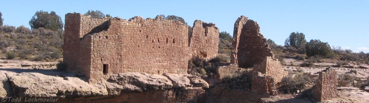
Research suggests that Hunter-gatherers (nomadic Paleoindians) visited the Cajon Mesa around 10,000 years BC to gather food and hunt game. They used the area for centuries, following the seasonal weather patterns. By about A.D. 900, people started to settle at Hovenweep year-round, planting and harvesting crops in the rich soil of the mesa. By the late 1200s the Hovenweep area was home to over 2,500 people. Typical pueblos included kivas, towers, and dwellings made with triple coursed stone masonry walls. It appears that the Ancient Pueblo People abandoned their communities in the early 1300s, perhaps due to drought, thought to have spanned 23 years. [ The current Colorado Basin drought is twenty years - good to have reservoirs to soften its effects. ] Two murals from Hovenweep were excavated and conserved. They are at the Anasazi Heritage Center.
The Visitor Center is at Little Ruins Canyon, which contains the Square Tower Unit, the most visited site in Hovenweep. The other ruins are more difficult to reach. Cajon is nine miles southwest of the visitors center on county road 413 and Navajo spur 405 at the head of Allen Canyon. Northeast on county road 212 in Utah into Canyons of the Ancients National Monument on country road 10 in Colorado is Holly at the head of Keeley Canyon, Horseshoe in Horseshoe Canyon and Hackberry in Hackberry Canyon, and the trail to Cutthroat is 4.5 miles farther on county road 10. Goodman Point Pueblo, the largest unit, is distant to the east in Goodman Canyon inside Canyons of the Ancients National Monument, near Delores, Colorado. It is interesting how the NPS places part of Hovenweep inside another national monument managed by the BLM.
Photo Gallery contains photos of Hovenweep National Monument with an auto-show of the photos.
Outlier map shows county roads and trails to all units except the distant Goodman Point.
Goodman P[oin]t map locates it inside Canyons of the Ancients.
Wide area map is a highway map with Hovenweep in the center of the Trail of the Ancients.
Explore Sq[uare] Tower Trail and Hovenweep Info[rmation] are graphics of Square Tower Trail around Little Ruins Canyon and the Square Towers Unit.