Little Colorado River Gorge
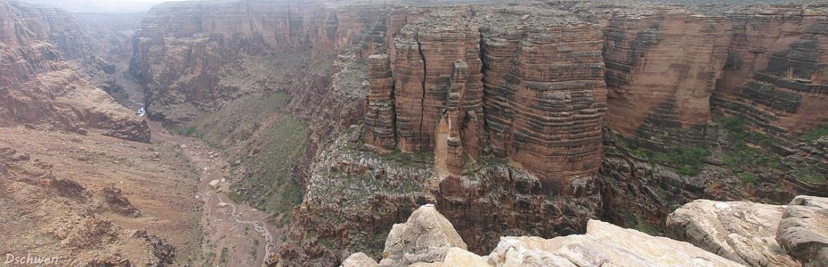
Little Colorado River Gorge is pristine, narrow, deep, and quite isolated, inside Navajo Nation. The Little Colorado River begins on Mount Baldy in the White Mountains in east-central Arizona, and flows 315 miles through a number of deep gorges and canyons, over the lava-flow-created natural dam at Grand Falls, and through this gorge between Cameron, Arizona, and the confluence with Colorado River in the Grand Canyon.
Flowing west, then north from Cameron, the Gorge makes a rapid 2,000 ft (610 m) descent in elevation in just 30 miles (48 km) to the Colorado and the Grand Canyon. There are two official viewpoints, one with an entrance fee at AZ64 mile post 185-186, and a free viewpoint 5 miles west, with a half-mile hike to a promontory. The highway is near the canyon in a number of places where a short hike takes one to the edge with magnificent views with trails into this deep, narrow canyon. Although most visitors experience the sights and wonders of the Gorge from above, hikers and backpackers will find the Gorge an outdoor wonderland with a rich history and navigable trails for all hikers' levels. [ Navajo Nation Parks, paraphrased ]
The Little Colorado River is a quite interesting study. It begins at Mount Baldy in the White Mountains at elevation 10,000 ft (3,048 m) and flows northwest for 315 miles (507 km) to Colorado River in the Grand Canyon at elevation 2,700 ft (823 m). It wanders north along the eastern edge of the Mogollon Rim, then turns around abruptly as it flows south into the Colorado. It has not always been so dry - three dams far upstream capture much of the snow-melt and upstream tributaries for irrigation. It flows through many canyons and gorges until reaching Cameron at US89. For the final 40 miles or so it flows through the pristine and very deep Little Colorado River Gorge inside Navajo Nation for the balance of its journey to the Colorado River in the Grand Canyon at its junction with Marble Canyon, and formerly the eastern boundary of the national park before its extension in 1975.
The Photo Gallery contains various-sized photos of the geology and scenery of the Little Colorado River Gorge, includes an auto-show of the photos in the gallery.
The Satellite image is a Google Earth satellite view of the Gorge from near Cameron to its confluence with Colorado River in the Grand Canyon, with an insert pointing to the Navajo Nation Park site - the first official viewpoint along AZ64.