The road looked as if it had been cut out of the red clay mountains with a pocket knifewrote Sharlot Hall about her trip down the side of the canyon to Lee's Ferry in 1911. Select Sharlot Hall on the menu for an historical photo and the rest of her story.
Historic US89 & Navajo Bridge History
Lee's Ferry was constructed in 1871, the only crossing of the Grand (eventually Colorado) River between Moab, Utah, and Needles, CA, a distance of 800+ miles. Automobiles on a rural road between Thistle, Utah, and Flagstaff, Arizona, started crossing the Grand in the 1920s using an unsafe ferry, thus becoming an important passage for settlers and travelers. The road was named US89 in 1925.
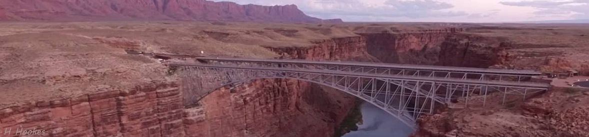
Construction of the US89 Grand Canyon Bridge over Grand (Colorado) River in Marble Canyon began in 1927, a short distance downstream from Lee's Ferry. In 1928 the ferry capsized, drowning three men and dumping a Model T into the river. With the bridge nearing completeion, the ferry did not reopen. The Grand Canyon Bridge opened for traffic in 1929, was renamed Navajo Bridge in 1934. By 1934, US89 was a 1,685-mile border-to-border highway from Mexico to Canada.
When the Glen Canyon Dam Bridge was finished in 1959, US89 was rerouted over the new bridge, and US89 between Kanab, Utah, and Bitter Springs, Arizona, crossing Navajo Bridge, became US89A. In 1990, it was decided that the traffic flow on US89A was too great for Navajo Bridge, that a new bridge was needed. The new Navajo Bridge over Marble (& Grand) Canyon opened for traffic in May, 1995.
With I-19 covering the exact route, US89 between Nogalis and Flagstaff was decommissioned as a federal highway in 1992, becoming part of the Arizona state highway system. Scenic Arizona highway AZ89 through Prescott and highway AZ89A from Prescott through Sedona, is historic US89, rejoining US89 in Flagstaff, where it resumes its route to Canada (although it is not signed as US89 inside Yellowstone National Park).
The United States Geological Survey, Federal source for Science about the Earth, its natural and living resources, natural hazards, and the environment We now turn our attention to a story of intrique concerning the naming of the bridge and the river and canyon it spans. So Grand Canyon Bridge opened over Grand River in Marble Canyon, and, at its side, Navajo Bridge opened over Colorado River in Grand Canyon? Confused by the disparity in the names? So were we - but we are not alone, considering that the USGS considered the river to be Green River, and the The National Park Service - charged with the care of our national parks and monuments NPS gives differing boundaries for Grand and Glen Canyons in its publications. So we conducted a study in an attempt to reconcile this confusion, which we call Satire on a Parody of Names - the Satire link on the menu. We attempt to document the changing names of the river (Grand/Green/Colorado) and canyons (Grand/Marble/Glen) over which Navajo Bridge resides, with NPS maps, and a self-debate over the controversies surrounding all of this.
View Photos is an auto-show of four scenic views of Navajo Bridge. 1929 Photo is an historic black-and-white photo of the bridge when it opened in 1929. Sharlot Hall tells her story of dropping down the the side of the cliff to Lee's Ferry in 1911. US89 Map is a map of traditional US89 from Mexico to Canada, showing the seven National Parks along the way. Landslide! has three AZDOT videos about the landslide at the top of Echo Cliffs just north of Bitter Springs that closed US89 for 25 months. the Satire discusses the naming of the bridges and the canyons and their rivers, and the boundaries of Marble Canyon National Monument, Grand Canyon National Park, and Glen Canyon National Recreation Area.